
Editors' Picks

Here are the last two days of our West Anatolia journey with journalist Koray Muratoğlu, photographer Engin Irız, and New Ford Ranger Wildtrak! See you on new road adventures, enjoy reading!
Article: Koray Muratoğlu
Photos: Engin Irız
Distance: 186 km
We spent the night in a new hotel located just below the ancient city of Sagalassos, which mostly serves the visitors of this city. The weather was quite cool as we were at about a thousand meters of altitude. It was as fresh as it was cool, and the scent of the Taurus was everywhere... After sleeping under these conditions, it is not possible not to feel amazing when you wake up by seeing the light of the highs of the Mediterranean. After leaving Ağlasun today, we will make the day finale in Antalya. Therefore, we do not have an exceptionally long way, it is about 130 km. However, as we have a Ranger and dive into the Taurus Mountains, of course, we would not ride straight down to Antalya just like that. If you want, you can drive down this path for a week. As you know, the ridges of Antalya are full of places to explore! There is almost another Antalya; the city which is always regarded as summer, beach, and sea, has an incredible potential apart from sea holidays, some will know...

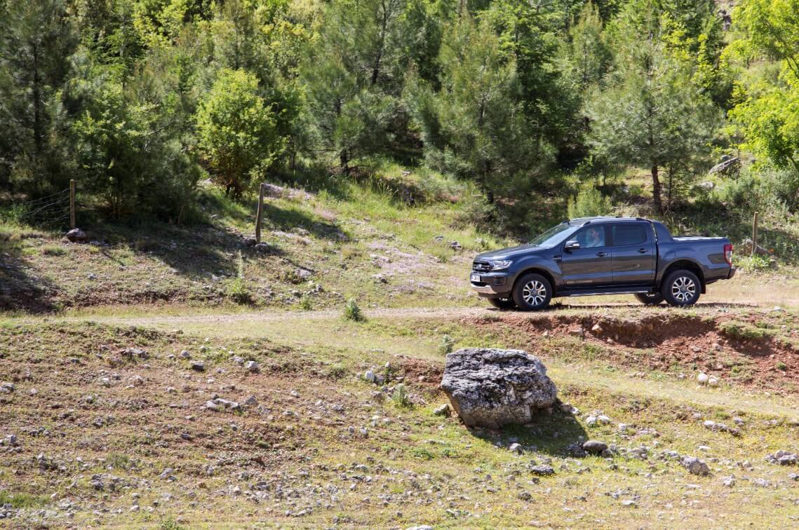
After leaving the district, we travel on a wide road with a beautiful asphalt of 22-23 km with the same exquisite forest views. Meanwhile, a dirt road I saw on my right makes me wonders as "hey, it seems to be going somewhere nice?" so I immediately leave the route and take the path. Of course, setting the Ranger to four-wheel drive mode again.
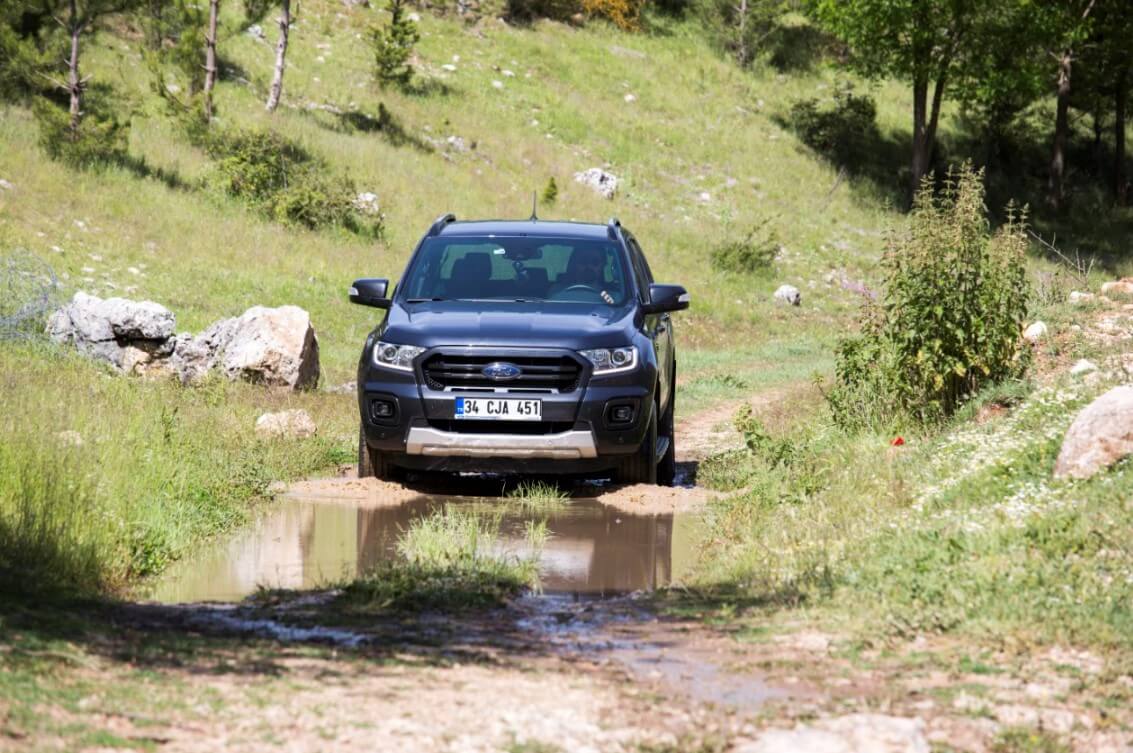
We dive in the pure green; the grass is grown even on the dirt road. At one point, I could not notice the mud and I got into the danger of sinking. My tires are not "all-terrain" or "mud terrain", but an asphalt-heavy tire. However, when the altar is switched to "Low" mode, the Ranger slips out of the hidden mud without the need for a specific tire.
I learn from a shepherd brother that after following the path for a little while, you can reach the main road after 10 km. As the main road was always within sight, I was guessing that. After a good dirt session, we reach the asphalt again. After a short while, after passing the Köroğlu Beli at the altitude of 950 m and starting the descent, we arrive at the Isparta-Antalya line.
Now, as I said, the rest from here can be Antalya quickly, but I cannot resist when I see the direction signs for a few villages on the right side, which are obviously highland villages, and we have time anyway. Without thinking much, I break the Ranger's steering wheel towards the mountains, and after climbing 15 km, we reach to the roof of the Taurus Mountains. The majestic Tauruses are under our feet. After we get off, watch a while, and take some photos, we drive back to the main road. That is what adventurousness is! But my treacherous plans are not over yet...
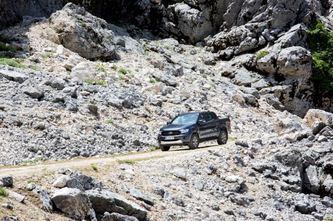
I have a "Bonus" idea about Ancient Cities. That is Kapıkaya Ancient City that I always saw the sign but did not have the opportunity. This is an archaeological site discovered in the 1850s, located in a difficult area, and not much uncovered yet. To reach there, you have to drive by Ağlasun and climb up to the Isparta-Antalya mainline and after 6 km you take a turn to the left towards Güneyce Village, as you would see the brown sign for Kapıkaya, then pass through a stony stream bed and ride on a road that resembles Alpine roads. One can drive for miles on this road. But after driving for 7 km, I turn right and enter a challenging 3 km. This is a short off-road sector where cars may get challenged, but Ranger would not mind at all; so, we overcome without problems. And we arrive at Kapıkaya, which is impressive for its steep cliffs and cliff-like slopes rather than the ancient city features. The reason of its name, the "Gaterock", can be understood from those huge rock walls. If Peter Jackson had seen here, he could have used it for "The Lord of the Rings", I am not exaggerating (okay, I might have exaggerated a little).
Back to the short off-road, what will we do on that "Alpine" counterpart path? We do not take to the main road on the left, but the "adventurous road extension festivities" continue. We are going to Kovada Lake. There are roads linking from here to there. I am determined to drive down to Antalya by showing the ear from the opposite side. Turning right, I will reach Kovada Lake after 27 km, but the road goes so well only for 7-8 km, after Çukurköy, let alone the great asphalt, it turns into a dirt road. Let us take it as a footnote, so far, it is a great road for bikers. This sharp change is not a problem for us, of course.
I enjoy the 14 km long dirt road on Tauruses, where we never saw any vehicles or people by forcing the Ranger a bit. This would be a genuinely nice road for a rally stage, so this is another footnote. At the end of the road, we will connect to the Eğirdir-Antalya line, but the roads in the village where we arrived are closed due to the asphalt paving works. I end at such ridiculous places that I suddenly find myself at the entrance of a cherry garden. There are employees in the garden, they say "come in" with the hospitality of the Anatolian people. When we explain the situation to them, they also make a bit of reproach "they rugged our roads"... They do not just send us on our way just with directions, of course, we also receive a bag of fresh cherries on the back seat.
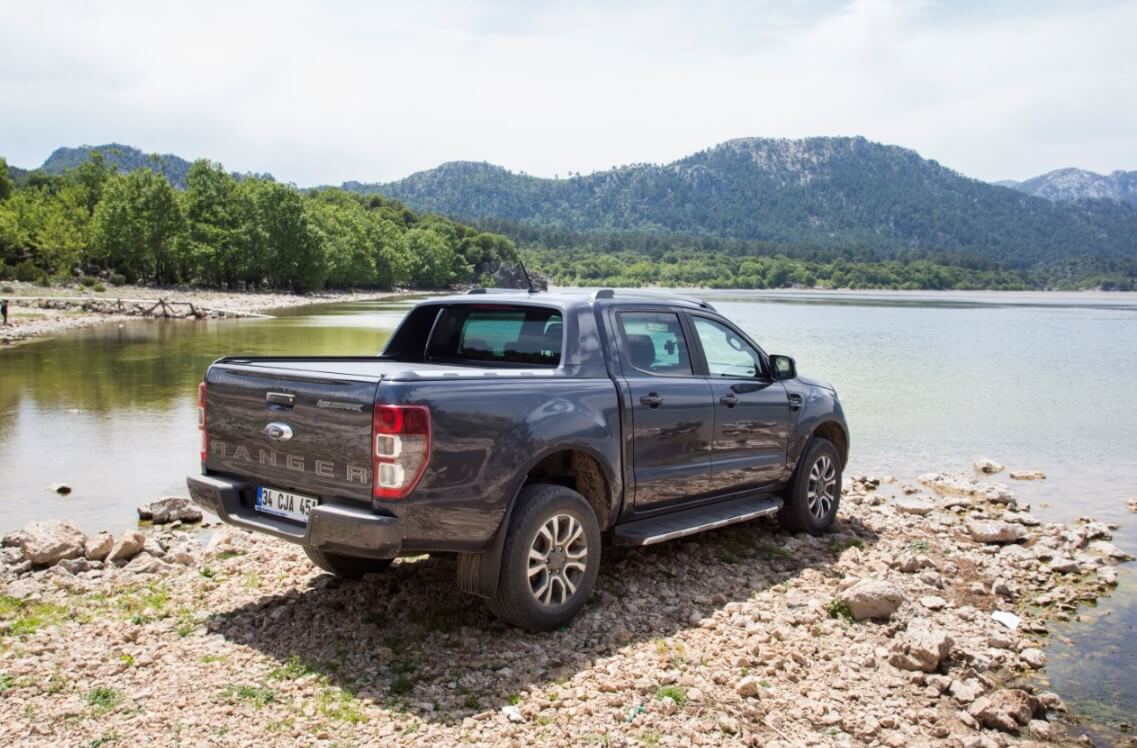
Anyway, we reach Kovada Lake after 5 km. Kovada is an extension of Eğirdir Lake, its surroundings are covered with extraordinarily rich vegetation. Therefore, it is a region that is quite rich in wildlife and immensely popular with bird watchers. There are also ideal areas by the lake for camping. At the same time, you can find facilities that are not too big due to being a National Park. We take a tour around the lake; the surrounding roads are also having exceedingly high quality. As such, I make one last stretch of road; going further south of Kovada, I climb to the Isparta-Antalya axis of the beginning of the day through the side roads that I probably will never have the opportunity to cross again. In fact, it does not take too long, I set off on the main road by riding 40 km more in total. However, of course, that beautiful asphalt around the lake does not continue. It even has an old road character with short stabilized parts from time to time. Well, is that a problem for us? Not at all...
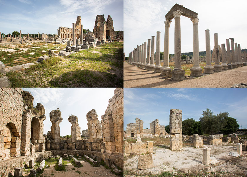
Perga
Perga Ancient City is an important city in terms of planning in the context of Late Classical, Hellenistic and predominantly Roman Empire periods. The plan applied to the acropolis in the Late Classical Period was carried to the lower city with the expansion in the Hellenistic Period. The colonnaded street that forms the north-south axis of the lower city is notable as a well-preserved example within the framework of urban planning. On the other hand, the water channel that runs through the north-south colonnaded street is an important design in this sense. The canal, together with four monumental fountain structures and two large baths in the city, gave Perga a “water city” identity in the warm Pamphylia plain. The defense system built in the Hellenistic Period and repaired in the Roman Imperial Period and Late Antiquity is another element that highlights Perga. The fortification wall, towers, bastion, and gates around the lower city are mostly erect. Considering the walls of the Acropolis, Perga appears as a valuable source of information on ancient military architecture. Perga Ancient City is suggested to the UNESCO World Heritage List with the above-mentioned qualities. Source: Ministry of Culture Inventory, Ankara
It was a day that we pushed the limits of the pleasure of driving and exploration in nature, inside the Taurus Mountains, on the ridges of Antalya. Now, we will reach Antalya by traveling an additional 60 km by the main road. As you know, this is a usual, double lane intercity road. Yet, we complete the descent with beautiful landscapes. It is quite easy to reach the largest ancient city of the Mediterranean, Perga, the last stop of the day, from the center of Antalya. In fact, Perga is almost inside Antalya. You suddenly arrive at the ancient city right after the traffic lights and the grocery on the corner etc. After the hustle of the day that I created deliberately, now I am trying to listen to the 2500 years old sounds under the yellow Mediterranean sunlight, sitting on a big column. Another day fades away such, as the city, never to be revived again...
Distance: 75 km
In fact, today can be described as a "giveaway", so to speak. The last ancient city in our plan is Phaselis in Kemer. If we were to go for it, we could have reached here after Perga at the end of the fifth day, which is yesterday. But we wanted to grant ourselves the luxury of making the last day a little more enjoyable, slowly, that is, by "hanging out". After resting on a not-hot Antalya evening, we set off before noon. Mediterranean coast had already started to give little alarms about the temperature. Still, the terrible heat that we know of had not begun.
Our route, compared to the past days, is nothing. It is 57 km from Antalya to Phaselis, and 75 km from where we stayed. If we wish to extend it today, I can climb up from Konyaaltı and descend to Kemer from around Sivri Mountain via Söğütcuma, but I said that today we will be a little calmer and fulfill our last mission. By the way, if you visit here, I suggest you pass through these locations that I have mentioned above. At the first World Rally Championship in Turkey, the Rally of Turkey was done in this area, so I know it very well and I can guarantee that you will find immensely highland roads and geography. As I said, "Another Antalya", that is it...
Our last sector is the classic Antalya-Kemer coastal road, it is likely that you have ridden on it many times. We drove while watching the dark blue Mediterranean on our left and the mountains covered with green and magnificent pine forest on the right side. There would often be roadworks around here, but now they are all completed. We arrive in Kemer; Phaselis is 15 km away from Kemer. You can see the sign on the road. After turning towards the coast, you will see the entrance in 1 km.
Phaselis
The ancient city of Phaselis said to have been founded by the colonists of Rhodes in the 7th century BC on a small peninsula extending to the Mediterranean. In its foundation legend, it is told that the colonists' suggestions of corn or dried fish to the local people were answered with the request of fish. Its geographical location indicates that it was an important port city. It has three harbors, one on the north of the peninsula, the other on the northeast, and the third on the southwest coast. Ship depictions on harbors, agoras and city coins emphasize Phaselis' identity as a commercial port. Phaselis is sometimes shown as the city of Lycia and sometimes Pamphylia region. It is located between the borders of both regions. The city was dominated by the Persians in the 5th century BC, then Mausolus the Satrap of Caria in the 4th century BC and finally the King of the neighboring city, Lmyra. Welcoming Alexander the Great with a golden crown in 333 BC is one of the most colorful pages in the history of the city. Phaselis, which had seen many rulers after Alexander, joins the Lycian League in 167 BC and minted the coins of the league. After being plundered by pirates with the neighboring city of Olympos for a while, it falls under Roman rule in 43 BC, which marks the start of restructure and prosperity of the city that would last at least 300 years. The city is visited by Emperor Hadrian in 129. The monumental arch with a single arch at the entrance of the main street starting from the south port was erected in memory of this visit. The city was under Byzantium rule during the 5th and 6th centuries and among the cities that participated in the Council of Chalcedon in 451. After the Arab invasions in the 7th century, a new period of prosperity begins in the 8th century. Following the Seljuk siege in 1158, Phaselis lost its importance after both the earthquakes and the loss of functionality of its harbor and it was completely abandoned in the early 13th century. Mostly Roman and Byzantine ruins have reached today. These are lined on both sides of the main street that forms the main axis of the city and connects the north-south ports. The street expands between the agora and the theater, creating a small square. Steps in the southeast corner of the square provide access to the theater and acropolis. The theater is a typical small size Hellenistic Period theater. It is understood from the remains that the stage building was added during the Roman period, and its wall in the Late Byzantine became part of the new walls that protected the city. On the right of the bend at the entrance to the ruins, there lays the old walls of the city (3rd century BC) and some building foundations, which might be a temple or monumental tomb. The slope behind the northern port is the city's cemetery. Source: Ministry of Culture Inventory, Ankara
Being a coastal city is the most important feature that distinguishes Phaselis from the places we have visited so far. It is a port city that has preserved its importance under different civilizations for a long time. It is also a beach, a paid beach like entering a museum. You can sunbathe among the centuries-old ruins and go swimming among them. After visiting the ruins spread among the pine trees, we leave the ruins.
At the end of the six-day journey, we have traveled approximately 1,200 km. This journey, which I call the "Western Anatolia Ancient Route", was a route that connects beautiful ancient cities and includes as many alternative routes as possible. We started from the northern coasts and went down to the southern coasts of the country. We had a great "Road Trip" in the Aegean - Mediterranean geography. We were on the road for 6 days. Except for the sleeping at night, Ford Ranger Wildtrak was my home. We run after the roads from morning till night. The goal was to be on the road anyway, the target was an argument we used in a Machiavellian language; our wish was to be on the move, move, and move... I am sure there will be a pleasant taste in your mind after you read this story. However, it would be so much incomplete in comparison with what I lived, saw, heard, smelled, and felt in brief. Therefore, I hope you will have the opportunity to put this prescription into practice. Then you will understand better what I mean...
The end...


